All data behind the BSBI Plant Atlas 2020 are now freely available on Zenodo. Based on over 50 million records, around 30 million of which newly collected, these datasets provide all the information required to reproduce all maps and charts featured in the two Plant Atlas volumes and the accompanying website.
Comprised of ten different datasets, the Zenodo Plant Atlas 2020 collection features the following:
- Distribution data at both 2 and 10 km, the latter broken down by BSBI date-class.
- Effort-adjusted 10 km distribution trends for all geographical units presented on the website, summarised in a variety of ways (non-linear, linear, and discretised-linear).
- Phenological data for the majority of species, both flowering (/spore-producing) and leafing ranges.
- National conservation statuses for a variety of countries and legislations.
- National native/non-native statuses for Britain, Ireland, and the Channel Islands.
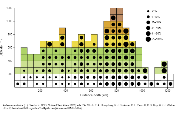
- Altitude-by-latitude diagram data for Britain.
- Weekly apparency estimates for 2000–19, including a by-latitude breakdown for Britain.
Whilst the Plant Atlas 2020 website already allows most maps and charts to be downloaded as images, the provision of these data as open resources will open up new research opportunities, and allow others to experiment with novel visualisations approaches.
All datasets are published with DOIs for citation purposes, and we looking forward to tracking innovative uses of these over the years to come!